Kenscoff: The Map Foretold It All
First published in Le Nouvelliste on 20 April 2026. Read on lenouvelliste.com ↗
Translated from the French original. In case of discrepancy, the French text prevails. Read the French original
On the night of 13 to 14 April 2026, the attack on Séguin, in the Sud-Est department, left at least seven dead, burned down the police station, and destroyed two police vehicles. This column shows that the advance could be read on a map long before it turned deadly.
April 2026
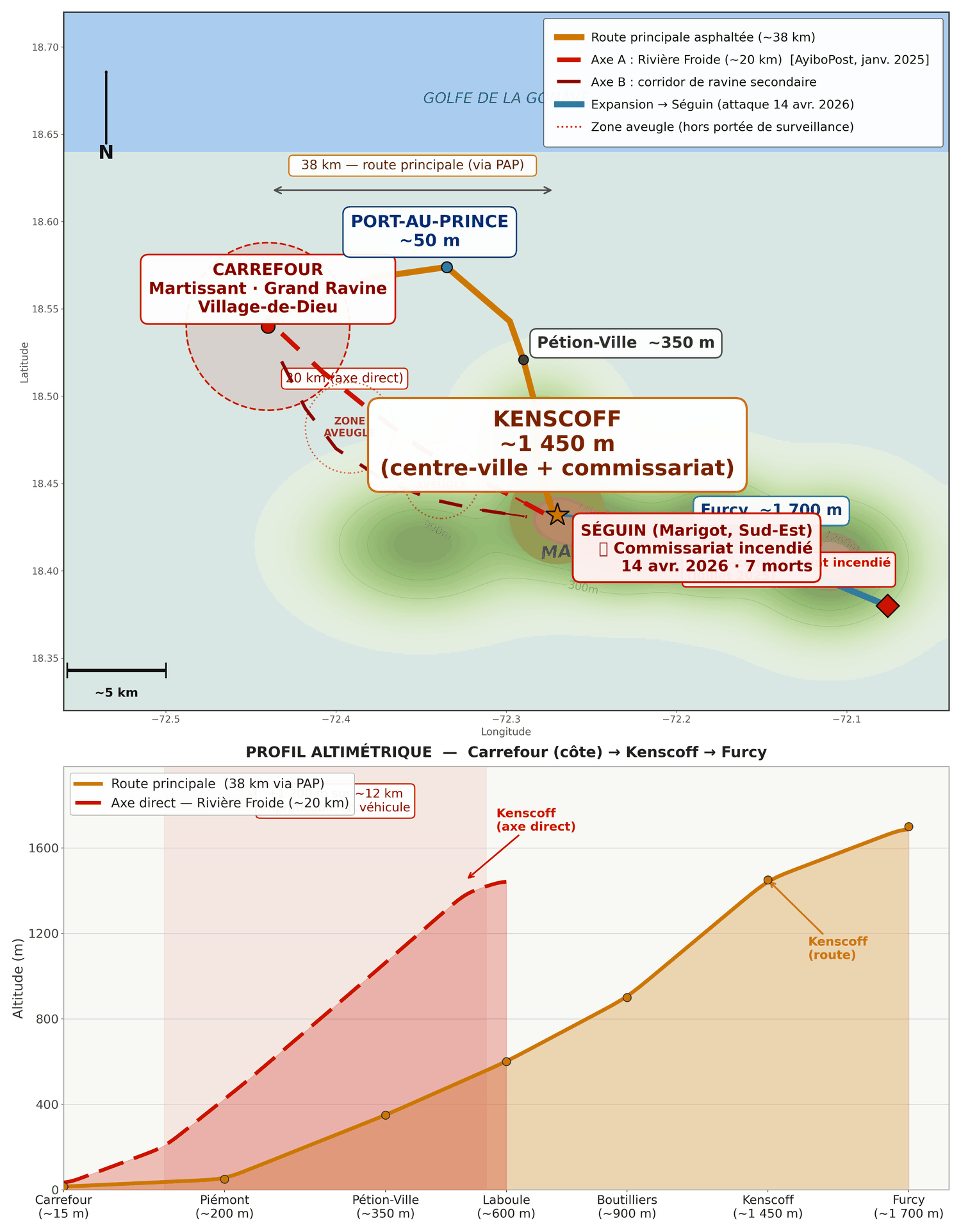
On the night of 13 to 14 April 2026, members of armed groups affiliated with the Viv Ansanm coalition (“living together” in Creole) attacked the village of Séguin, in the commune of Marigot, in the Sud-Est department. The toll: at least seven dead, the police station burned down, two vehicles of the Haitian National Police (PNH) destroyed. Among the victims were young men described as police informants, shot and then burned on the spot.
This was not an isolated incident. It is the continuation of a script that the geography of the Massif de la Selle had written long before the attack on Kenscoff in January 2025. This piece does not go back over the events to assign blame. It asks a more useful question: if the map was writing this script, who knew how to read it? And above all: what does it say about what comes next?
I. Kenscoff: five strategic assets of distinct kinds
Before explaining how this terrain was infiltrated, we need to gauge what it represents. Military doctrine defines key terrain as any position whose control determines the outcome of operations over a wide radius. Kenscoff combines five strategic assets of fundamentally different kinds, which makes it key terrain several times over, a rare configuration that by itself dictates the intensity of the pressure exerted on it over the past fifteen months.
First asset: visual dominance over Pétion-Ville. An asset of a geographic and military nature. The town of Kenscoff sits at an altitude of about 1,450 meters (IGN Haïti / OpenStreetMap, ±50 m), towering more than 1,100 meters above Pétion-Ville. That commune is home to the functioning state institutions, the diplomatic missions, the active commercial districts, and most of the banking system. The United Nations Integrated Office in Haiti (BINUH) put it plainly: Kenscoff “is of strategic importance, as it overlooks the commune of Pétionville, where many institutions, banks, commercial areas, and embassies are located.”
Second asset: the Morne Tranchant telecommunications site. An asset of the critical-infrastructure kind. Its capture by Viv Ansanm in August 2025 disrupted internet connections and systems linked to air traffic control. This is not a local antenna. It is a node of the national network whose capture has an immediate, measurable effect far beyond the commune.
Third asset: the market gardens that supply Port-au-Prince. An asset of an economic and food-supply nature. Kenscoff is one of the capital’s main vegetable-growing areas. Its control by armed groups creates not just a security problem but a food-supply problem for a population already under strain.
Fourth asset: the corridor toward Séguin and the Sud-Est. An asset of a territorial nature. The clashes of January 2025 reached Ka Fonvyen and Nan Peno, which AyiboPost documented as opening onto Séguin. This corridor has nothing to do with civilian traffic to the southern peninsula, which has long traveled by sea and air. It concerns the territorial projection of the armed groups themselves: from the heights of Kenscoff and Furcy (~1,700 m), the southern slopes of the Massif de la Selle run naturally down toward the Sud-Est department. The attack on Séguin on 14 April 2026 confirmed this projection.
Fifth asset: the symbolic destabilization of the state. An asset of a political nature. BINUH identified it: the attacks also aim to “destabilize the authorities in place by exposing their difficulties in protecting one of the most residential areas of the capital.” Kenscoff is no anonymous outskirt. It is a commune of high social and political visibility whose fall sends a signal addressed at once to the population and to international partners.
Five assets of different kinds (geographic, infrastructural, economic, territorial, political), concentrated in a single commune. In Clausewitzian terms, Kenscoff is a secondary center of gravity whose loss simultaneously weakens five dimensions of state capacity. This fact of geography and territorial organization precedes any human intention.
II. The Massif de la Selle as a battlefield: what the map reveals before the first shot
Figure 1 is not an illustration. It is an analytical tool. It reveals at once why the armed groups can move freely through this massif and why law enforcement is structurally at a disadvantage there. Both realities stem from the same terrain.
The main road between the low-lying areas of Carrefour and the town of Kenscoff runs about 38 kilometers, by way of Port-au-Prince and Pétion-Ville. It is the only route passable for PNH vehicles. The Rivière Froide valley corridor, documented by AyiboPost as the infiltration route on the night of 26 to 27 January 2025, covers some 18 to 22 kilometers in a straight line (map estimate, ±10%). Impassable for standard vehicles. Accessible on foot and by off-road motorcycle. This is the principle of interior lines, theorized since the eighteenth century: whoever has shorter lines of approach that cannot be intercepted keeps a decisive mobility advantage even against a numerically superior force. Here, the armed groups cover 20 kilometers along unwatched corridors while the PNH is confined to 38 kilometers of predictable road. This ratio is written into the topography. It does not change with operations.
The elevation profile in Figure 1 shows why these secondary corridors are so hard to watch. The 1,450-meter difference in elevation over 20 kilometers carves deep ravines running perpendicular to the ridge, steep-sided gullies invisible from the main road below. That is the first tactical effect: a group moving up the Rivière Froide passes beneath the detection threshold of any surveillance conducted from the roads. The 20-kilometer infiltration can take place without passing a single checkpoint. But the same ravines produce a second effect, the reverse of the first and simultaneous with it: their side walls completely dominate the floor of the gully. A group positioned halfway up a wall controls everything that moves below without being visible from beneath. For the units that enter these ravines, the problem is not the distant ridge. It is the wall right beside them, a few dozen meters away, within firing range. The ravine shields the infiltrator from outside surveillance while exposing the unit that searches it to ambush from its own flanks.
For a standard police unit, the terrain of the massif has three further effects. First, the loss of vehicle mobility: armored vehicles and pickup trucks are tied to the main road, which makes any advance off the paved route impossible with standard equipment. Second, physical fatigue: advancing on foot up a 1,000-meter climb through ravine country requires specific conditioning and equipment that urban police units do not necessarily have. Third, disorientation: in the deep ravines and wooded areas, visual navigation is impossible. Without precise operational mapping, a patrol advances through a space it does not control, facing an adversary who knows it.
These constraints are not peculiar to Haiti. They explain why seasoned armies maintain units devoted exclusively to mountain warfare. France keeps the Chasseurs Alpins, whose training lasts several years and covers navigation on vertical terrain, high-altitude combat, and movement through steep, enclosed ground. Italy has its Alpini, Austria its Gebirgsjäger, the United States its Mountain Warfare Training Centers. These structures exist because mountain terrain demands skills that do not carry over directly from urban or lowland combat. Asking a police unit trained for Port-au-Prince to control the Massif de la Selle means pitting a doctrine against terrain it was not designed for. Security Council document S/2025/356 (June 2025) confirmed the material gap: at the time of the first attacks, the security forces lacked “helicopters, all-terrain vehicles, motorcycles, and drones.”
III. The dynamics of expansion: opportunity in 2025, escape valve in 2026
Two different logics, belonging to two different periods, must be kept apart, because conflating them produces an inaccurate analysis. In January 2025, the PNH was still in a defensive posture in the low-lying areas of Port-au-Prince. The initial attacks on Kenscoff were not a response to pressure from the plain. They followed a logic of pure strategic opportunity: key terrain concentrating five distinct assets, unprotected by a suitable security architecture. The armed groups acted because they could, not because they were pushed.
The dynamic shifts from late 2025 into 2026. The PNH goes on the offensive in the low-lying areas: operations in Bel-Air, Delmas 4, and downtown. Le Nouvelliste reports that armored vehicles operated in Martissant for the first time in several years, that police substation having been out of state control since June 2021. This pressure shrinks the armed groups’ operating space on the plain. It is in precisely this context that the Rivière Froide corridor takes on added value as a fallback route: it opens onto mountain terrain to which offensive pressure has not yet extended. They are not fleeing an offensive. They are making for a space where they remain free. The mechanism is geographic: the massif’s interior lines, shorter and unwatched, remain available whatever operations are carried out on the main road.
The attack on Séguin on the night of 13 to 14 April 2026 extends this logic. The pressure spread from Kenscoff to Furcy, from Furcy to the massif’s southern corridor, all the way to Marigot in the Sud-Est department. Each stage along this corridor was less closely watched than the one before. Seven dead, a police station burned down, two PNH vehicles destroyed. The same method, the same hour, the same type of target as in Kenscoff over the past fifteen months.
IV. Predictability: reading the map to see what comes next
Analyzing the predictability of a past event is not about assigning blame. It is about showing that a geographic script exists, that it can be read, and that understanding its logic makes it possible to anticipate its next scenes. Anyone who had read the map of the Massif de la Selle in 2024 would have seen January 2025. Anyone who reads it today can see what follows Séguin.
Six indicators could have been documented before the January 2025 attack. First, the expansion vector of the Grand Ravine and Village-de-Dieu groups, whose systematic advance toward the northeast and the heights was documented in BINUH’s quarterly reports (2024), with the Rivière Froide corridor as a direct link to Kenscoff. Second, the concentration of the five assets without a suitable defensive architecture: a police station in the town does not cover the massif’s secondary routes. Third, a voice message circulating on social media eight days before 27 January 2025, warning of an imminent attack, without local intelligence being able to pinpoint where. Fourth, between 75 and 100 armed individuals prepositioned inside the commune before the main assault, according to BINUH, their numbers rising from a few dozen to several hundred within days without any institutional detection. Fifth, a five-hour delay in deployment: despite the warnings, the PNH intervened only after 24 people had been killed and 70 houses burned (S/2025/356). Sixth, the complete absence of coverage of the secondary routes: no one was watching the Rivière Froide.
The convergence of these six indicators was not a surprise. It was a script. Séguin was its next scene, made predictable from the moment the clashes of January 2025 reached Ka Fonvyen and Nan Peno. Whoever reads this map today can see that the southern slopes of the massif are not where the script ends.
V. Clear without hold: why tactical victories do not add up
Counterinsurgency doctrine breaks the restoration of territorial control into three sequential phases: clear, hold, and build, the last meaning the rebuilding of authority. In Kenscoff, the clear phase has been mastered. The recapture of the Teleco site at Morne Tranchant on 25 August 2025, the sniper and drone operation of 20 to 21 February 2026 with sixteen confirmed neutralizations according to the official PNH statement, the many engagements documented throughout 2025: the security forces know how to clear an objective.
What is missing is the hold phase. After each operation, no permanent deployment holds the secondary routes by which the armed groups withdrew. Kenscoff’s interim executive agent put it plainly in July 2025: “several localities had recently been retaken by the police, but the failure to consolidate positions, owing to a lack of resources and personnel, allowed the gangs to regain ground” (AlterPresse). The cycle is mechanical: clear, withdraw, return. Without a hold phase, the build phase can never begin.
The difficulty specific to mountain terrain is that the hold phase costs proportionally more there than in an urban setting. Holding a retaken city block requires personnel on roads that vehicles can use. Holding a twenty-kilometer ravine corridor requires units able to operate off-road, at altitude, at night, with mountain equipment. It is not the same men with the same equipment in a different space. It is a different doctrine.
VI. What doctrine now requires
The Gang Suppression Force (GSF), whose first personnel are arriving in Haiti in April 2026 under Security Council Resolution 2793 (October 2025), has a suitable mandate: autonomous intelligence-led operations, geographic information systems, helicopter-borne capabilities. It is the right mandate. It must be applied with a doctrine that differs according to whether the terrain is urban or mountainous.
First: build a unit specialized in mountain terrain. Not an ad hoc adaptation of existing units. A permanent unit trained for movement over high-altitude terrain, navigation in ravines, and combat in steep, enclosed ground. The Chasseurs Alpins, the Alpini, and the Gebirgsjäger are available models. This know-how can be passed on.
Second: map the secondary corridors with operational precision. Resolution 2793 provides the GSF with geographic information systems for intelligence-led operations. Applied to the western flank of the massif, these tools make it possible to map the ravine corridors, starting with the Rivière Froide. Without such mapping, the forces cannot place interception points in the right locations. You can only watch what you have mapped.
Third: move from temporary garrisons to a permanent presence on key terrain. Morne Tranchant and the exits of the main corridors require a permanent presence, however light. The cycle of recapture and abandonment documented since August 2025 is the empirical proof of a simple doctrinal principle: key terrain that is not held after being cleared will be retaken.
Fourth: cover the night window. The attacks in Kenscoff and Séguin systematically take place between midnight and 5 a.m. That is the only window in which the PNH’s technological advantage is suspended. Helicopter-mounted thermal imaging closes this window: it sees body heat regardless of darkness and vegetation cover.
On the night of 13 to 14 April 2026, Séguin burned. Seven dead. A police station set on fire. The same script as in Kenscoff since January 2025, moved from one slope of the Massif de la Selle to the other. The map had written it. It was still announcing it after every attack, after every operation, after every recapture and every abandonment. The offensive under way in the capital is the doctrinal turning point the situation demanded. It is producing results where its tools are suited to the task. The Massif de la Selle now calls for the same rigor, translated into mountain doctrine. The map keeps on writing. The question is who is reading it.
Sources. AyiboPost (field reporting, January–February 2025). BINUH, Kenscoff flash report (April 2025), and Security Council document S/2025/356 (June 2025). AlterPresse (coverage, 2025–2026). Le Courrier de la Nation, RTPA, Juno7 (attack on Séguin, 14 April 2026). Le Nouvelliste (PNH in Martissant, 2026). Statements by the PNH and the Haitian government (December 2025 to April 2026). Security Council Resolution 2793 (October 2025). IGN Haïti / OpenStreetMap (topography, ±50 m in altitude, ±10% in distances).
Methodological note. This article applies standard frameworks of military analysis: terrain assessment (five criteria), the theory of interior lines, center of gravity (Clausewitz), and the clear-hold-build operational model (COIN doctrine). These frameworks are used for analytical purposes. The author is not a military professional and claims no operational expertise. All factual data are sourced as indicated in the header note. The analyses and proposals do not commit any institution.