Kenscoff: The Ridge Is Taken, the Mountain Remains Open
First published in Le Nouvelliste on 9 October 2026. Read on lenouvelliste.com ↗
Translated from the French original. In case of discrepancy, the French text prevails. Read the French original
In three weeks, the police have climbed the gangs’ route in reverse, from the town of Kenscoff to the edge of the plateau, and for the first time since January 2025 in the right order. This column follows that route from Carrefour, places on the terrain what September actually won, then sets out the three traps the terrain holds and what is still open: the last kilometer to the rim of the wall, Wynne Farm above the town, and time.
Since mid-September, the police have been retaking Kenscoff one locality at a time, and for the first time since January 2025 they are doing it in the right order. To understand what that is worth, you have to follow the route the gangs take to climb up, see where the police stand on it, and what still lies ahead of them.
On 26 September, the Haitian National Police (PNH) announced full control of Godet, Viard 1, Viard 2, and Bois d’Avril (Le Nouvelliste, 28 September 2026). On the afternoon of 6 October, the police added Belot and the Le Montcel hotel to the list. After two massacres in less than two months, these announcements were greeted with relief, and they deserve it. But a list of retaken localities says little to anyone who does not know where they are or what they are worth. An announcement says what has been taken; it does not say whether it can be kept.
To answer that question, you have to look at the terrain, because in Kenscoff it is the terrain that decides: who sees whom, who gets there first, and what a post placed here rather than there can prevent. This article therefore starts at the beginning. It describes the route by which the gangs climb, from the bottom to the top, naming along the way each feature of the terrain that will matter later. Once that route is in your head, it is easy to see what the police have really gained since September, what still lies ahead of them, the three traps this terrain sets for anyone who holds Kenscoff, and what remains to be done before one can say bravo and be right.
A word before we start climbing. Everything that follows rests on public sources: police statements, the press, the reports of the United Nations Integrated Office in Haiti (BINUH) and of the National Human Rights Defense Network (RNDDH), and a terrain model. The police know things these sources do not say, and they may hold positions they do not announce, which would in fact be normal. This article therefore does not judge what they are doing; it says what the terrain demands, and where the public announcements stood against that as of 6 October. It is for the police to say whether the gap is real or only apparent.
The route up, from Carrefour to Kenscoff
The gangs that attack Kenscoff almost all come from Carrefour, to the west. That has been established since the first massacre: BINUH’s April 2025 report describes armed groups climbing on foot from the plain, with donkeys loaded with ammunition. So let us start there, and climb with them.
Carrefour lies on the plain, at an altitude of 57 meters. For nearly nine kilometers, the ground rises in one long climb, about 10% on average, tiring but without obstacles, up to the area around Procy, a small village set on the slope at about 940 meters. Just past Procy, the route plunges into a ravine and drops back to 741 meters. That is where everything changes. From the bottom of that ravine rises a slope that gains 754 meters of height in just 2.1 kilometers. The average gradient is 36%, and the last kilometer, the highest, climbs at 40%. In this article, that slope is called the wall. It is the first word to remember, because it is the main obstacle between the gangs and the commune.
The top of the wall, where the slope suddenly stops, lies at 1,495 meters. That is the rim. Past the rim, the terrain changes completely: for about four kilometers it is almost flat, a gradient of barely 6%, rising gently. That is the plateau. Belot begins very close to the edge: the Le Montcel hotel, which is part of it, is barely a kilometer from the rim, 80 meters higher. Viard 1 and Viard 2, two small villages, lie at the entrance to Le Montcel (Karibinfo, 25 November 2024). Bois d’Avril is farther on, toward the middle of the plateau, at 1,679 meters.
At the end of the plateau, the ground rises one last time, to 1,755 meters. That is the ridge, the highest point on the whole route, 3.8 kilometers from the town of Kenscoff. From the ridge, the route goes back down. It first passes through Godet, a hollow at 1,561 meters, wedged between the ridge on one side and another height, Wynne Farm, on the other. Then it reaches the town itself and its police station, at 1,461 meters.
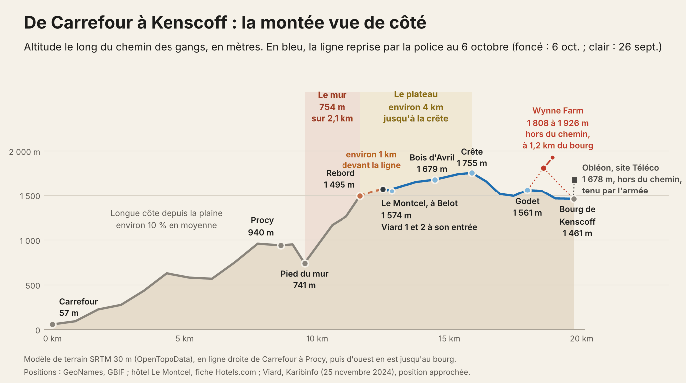
The diagram above shows this route from the side, as if the mountain had been sliced through: the long climb from Carrefour, the ravine at the foot of the wall, the wall, the rim, the plateau, the ridge, the hollow of Godet, the town. The ridge stands 1,700 meters above the plain, and nearly half of that height is gained over the two kilometers of the wall. Everything that follows can be read on it.
One last element remains to be put in place, and it is the town itself. Kenscoff does not sit on high ground. The town lies at the bottom, surrounded by heights that clearly overtop it: the western ridge at 1,755 meters, Obléon and its Téléco site at 1,678 meters to the north, and above all Wynne Farm, only 1.2 kilometers from the police station, at 1,808 meters for the farm and 1,926 meters for the antennas just above it. From Wynne Farm, you are 350 to 465 meters above the town center. On the profile, Wynne Farm appears in red and Obléon in dark gray. Neither is on the gangs’ route, but the first looks down on both Godet and the town, and the second has the town directly below it. This is what this article calls the bowl: the town at the bottom, three heights around the edges. Whoever holds the edges sees the bottom. Before the massacre of 23 August, the gangs flew drones over the center for several days (RNDDH, report of 16 September 2026): not to discover the bowl, which they know, but to find out where the armored vehicles were.
There is the setting: a wall, a rim, a plateau, a ridge, the hollow of Godet, and the bowl in which the town sits. With these six words, the September statements stop being a list of names.
What September changed
Let us go back over the timeline, placing it on the route. On 13 and 14 September, the gangs attack Viard, at the entrance to Le Montcel; the attack is repelled. On the 16th and 17th, the police go on the offensive in Viard 1 and 2, Godet, Bois d’Avril, Nan Kroupi, Belot, and Tèt Kavri. On the 20th, six hostages are freed with the support of the Gang Suppression Force (GSF) (Vant Bèf Info, 22 September). On the 25th, Bois d’Avril is retaken. On the 26th, the police announce full control of Godet, Viard 1, Viard 2, and Bois d’Avril. On 6 October, Belot and the Le Montcel hotel are added to the list.
Placed on the diagram, these names tell a single story. Godet is the hollow just above the town. Bois d’Avril is on the other side of the ridge, in the middle of the plateau, and between the two there is necessarily the ridge itself. Viard is farther still, at the entrance to Le Montcel. On 6 October, Le Montcel was added, a kilometer from the rim. In three weeks, the police have climbed the gangs’ route in reverse, from the town to the edge of the plateau.
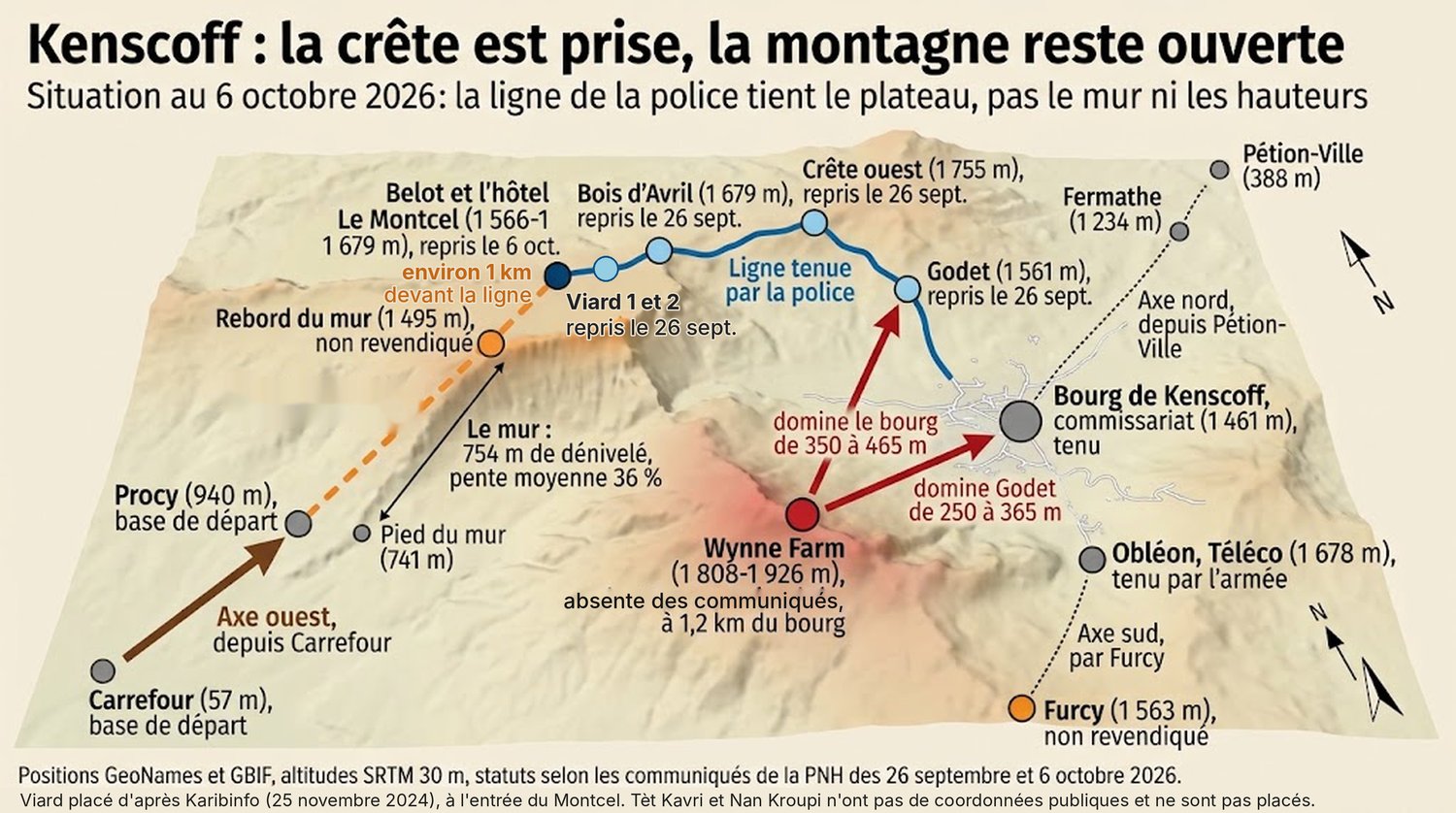
That is the real progress of September, and it is greater than people say. Since January 2025, every time the gangs came up, they found the state down below, in the town, and attacked it from above. Today, an attacker who reaches the top of the wall finds the police a kilometer ahead of him, and higher than he is. This is not a small improvement; it is a different situation. And since 26 September, no attack has been reported in the commune. Ten days of calm is very little, and we will see further on why; but it is the first time since July.
What still lies ahead
The operation is not over, and that is the first point to keep in mind. In three weeks, the line has moved from Godet to Le Montcel; it is still advancing, and Le Montcel was announced only on the afternoon of 6 October. What can be done today is to look at where the line stands on that date and what lies in front of it. It stands at Le Montcel, at Belot. In front of it, about a kilometer away, is the rim of the wall. Tèt Kavri, targeted as early as 16 September, is next to Viard: that is where attackers set out from to attack Viard 2 in June 2025 (Le Nouvelliste, 12 June 2025). Nan Kroupi has no public position.
Why does this last kilometer matter so much? Because the ground that is easiest to take is also the most useful to hold. Between Le Montcel and the rim, the ground slopes gently down. But whoever holds the rim forces the attacker to climb the 754 meters of the wall in full view, with nothing to hide behind, before he can fire a single useful shot. Whoever stops a kilometer short lets him reach the top of the wall, catch his breath on the plateau, and choose his moment. So it is the next step that matters most, and if the line keeps advancing at September’s pace, it is within reach.
The second point concerns the bowl. Of the three heights above the town, one is held with certainty: Obléon, where the army keeps a permanent post. The ridge lies inside the announced line. That leaves Wynne Farm, the highest of the three and the closest to the police station. The police have already operated there, on 20 February 2026, the same day as in Godet (Haitian Times, 22 February 2026); the September and October statements, which concern the western axis, do not mention it, which does not mean it is empty. It may be occupied without this having been said, or it may come later in the sequence of operations. The day the police say what the situation is there, residents who are hesitating to return will know what to expect.
The rim ahead, Wynne Farm above: those are the two places that the next phase will have to settle, and it is too early to say that it will not. If the article dwells on them, it is because the terrain of Kenscoff has already produced situations like them three times, and they turned out badly. These are the traps of the terrain. They lie in wait for any force, the best-intentioned included, and knowing them in advance is better than recognizing them afterward.
First trap: the hollow of Godet
Godet is the locality cited most often in official statements since January 2025. The security forces have returned there five times in twenty months. Since November 2025, they have returned on average every 99 days, and both massacres this summer took place between two of those returns. A locality that is retaken every three months is not held. It is visited.
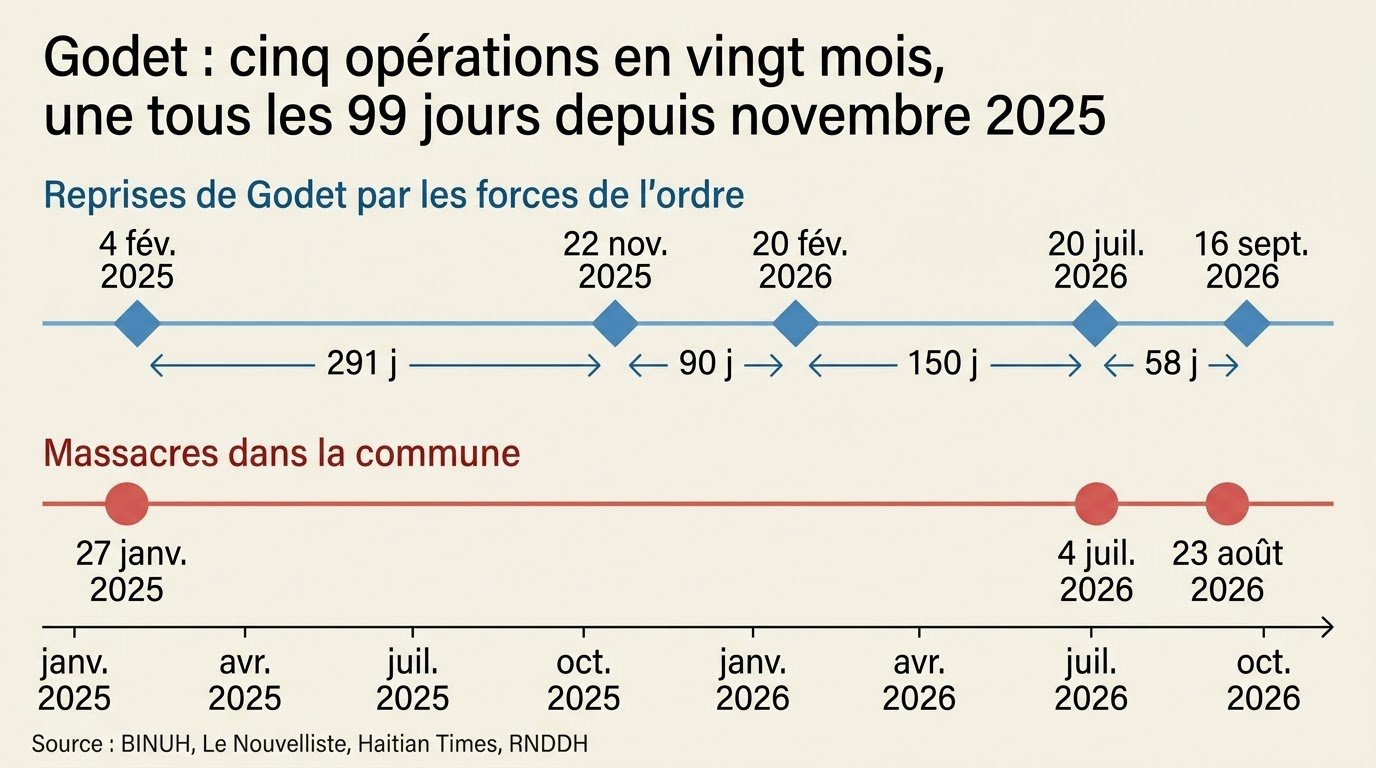
The terrain explains why. Godet is a hollow: the ridge on one side rises nearly 200 meters above it, and Wynne Farm on the other, 250 to 365 meters. A post in Godet is a post at the bottom of a small bowl, overlooked from two sides at once. You pass through a hollow; you hold it only by holding the two heights on either side. Each time the forces returned to Godet, the statements announced that the hollow had been retaken; none said whether the edges were held afterward, and they may have been for a while. What the series of five returns shows is only that whatever had been put in place did not hold in between. The same reasoning applies to the town: holding the police station without holding Wynne Farm means holding the bottom of the big bowl while leaving its edge to whoever wants to take it.
Second trap: the race for the ridge
In the mountains, whoever is on top has the advantage, on one condition: being in position before the other side arrives. An attack on Kenscoff is therefore first of all a race. On one side, the attackers climbing from the foot of the wall. On the other, the police reinforcements setting out from the town, where the police station and the reserves are. The finish line is the ridge: the highest point on the route, the one that commands both the plateau and the hollow of Godet.
This race can be measured. It is enough to count the way hikers do: one hour for every five kilometers of walking, plus one hour for every 600 meters of climbing. The attacker setting out from the foot of the wall has 6.3 kilometers to cover and more than 1,000 meters to climb: he needs about three hours. The police officer setting out from the town has 3.7 kilometers to cover and 360 meters to climb: 1 hour 20 minutes. On paper, then, the police have a lead of 1 hour 40 minutes, as the first two bars of the chart show.
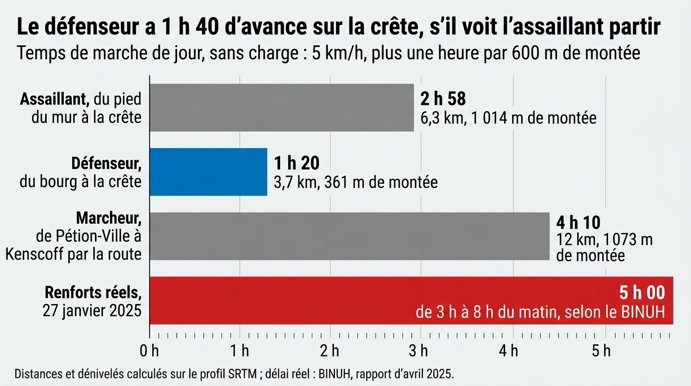
But that lead of 1 hour 40 minutes hides a condition, and that is where the trap lies. It is counted from the moment the attacker leaves the foot of the wall. Yet the police can set out only once they know he is coming. The whole question, then, is when he is seen.
The terrain answers, and its answer is harsh. From the ridge, nothing of the wall can be seen: the rim hides it entirely. From Le Montcel, a kilometer from the edge, you see no more of it. You have to stand on the rim itself to see the slope, and even then, according to the terrain model, you see only its upper half, because a bump halfway down hides the foot. Finally, the major attacks began at night, at 3 a.m. in January 2025 and at 10:30 p.m. in August 2026: at those hours, even a well-placed lookout sees nothing without night-vision equipment.
The next chart shows what this changes. If the attacker is spotted at the foot of the wall, by a drone or by a lookout posted on the slope, the police keep their lead of 1 hour 40 minutes. If he is spotted only halfway up, by a lookout posted on the rim, only about 45 minutes remain. If he is seen only as he reaches the top of the wall, both sides reach the ridge at about the same time. And if he is spotted only once he is on the plateau, the police arrive 20 minutes after him.
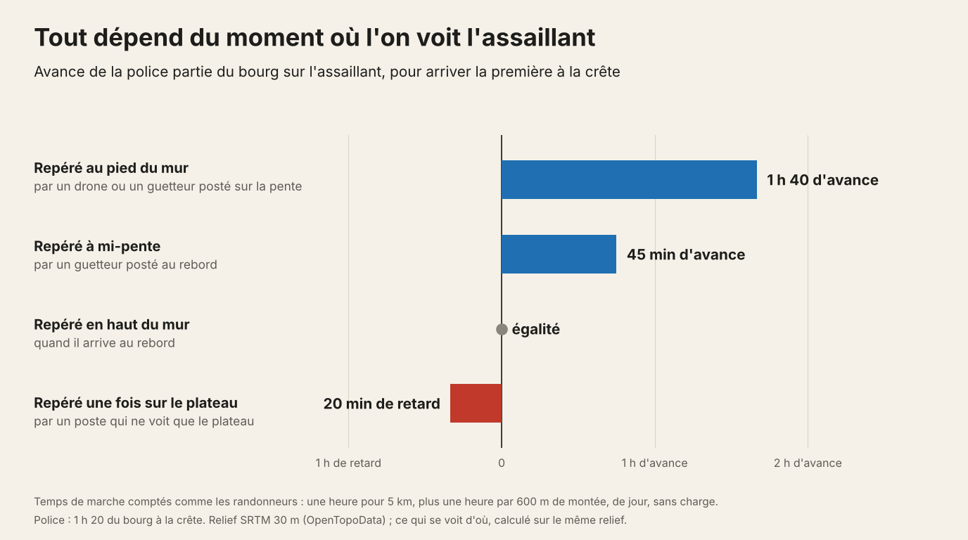
The trap, then, is to believe that holding the high ground is enough. The high ground does not deliver victory; it delivers time, and that time exists only if you see early. That is why the last kilometer, between Le Montcel and the rim, matters so much: it is the only place from which the slope can be seen. And that is why, in Kenscoff, drones able to fly at night over the wall count as much as more men at the top.
One last condition remains, shown by the last bar of the first chart: the reinforcements must already be in the commune. The whole calculation assumes that the police set out from the town. If the reserve is down below, in Pétion-Ville, it takes 4 hours 10 minutes of walking by road to climb up to Kenscoff. On 27 January 2025, the motorized reinforcements took five hours, from 3 a.m. to 8 a.m. (BINUH, April 2025 report). Five hours is nearly twice the time the attacker needs to climb from the foot of the wall to the ridge. A reserve stationed down below arrives after him, however good the lookouts are.
Third trap: the calm
This is the most dangerous trap, because the commune has already fallen into it once, and recently. Between the recapture of the Téléco site at Obléon, in August 2025, and the massacre of July 2026, the commune went 313 days without a massacre. That calm had not come out of nowhere. In November 2025, real posts had been set up, one by one: Téléco, Panyòl, the Sainte-Hélène orphanage, Viard 1, Kafou Malè, Carrefour Maroca (RNDDH, report of 16 September 2026). It worked: violence fell by 66% between January and August 2026 compared with the same period of 2025, according to the researcher María Fernanda Arocha of ACLED (statement of 25 August 2026).
Then, with the calm helping, the specialized units were recalled one by one to other fronts, and the number of police officers assigned to the commune fell by 60%, again according to the RNDDH. What weighed in these choices is not known: other communes were burning too, and the police have never had enough officers for every front. The police station asked for reinforcements in writing on 17 August, six days before the second massacre (RHINEWS, 2 September 2026). The calm had not been won for good; it depended on the posts, and it left with them.
This precedent sets two figures. The first: getting back to the level that worked in November 2025 means multiplying the number of police officers present in the commune by 2.5, not counting the hundred officers requested by the police station. The second: ten days of calm are worth nothing until they have lasted longer than the previous calm. The right threshold is one year without an attack, which means not before the end of September 2027. Before that date, bravo is a word you lend. After it, it is a word you can give.
Two figures that the statements do not give also weigh on what comes next. Zero known prisoners after the September offensive: the attackers who were killed will say nothing about the routes they used or about those who ordered the August massacre. And 65 hostages still held, if the six who were freed are subtracted from the 71 abductions counted by the RNDDH for July and August; a gang leader threatened to kill them all if any of his men was hit (AP, 26 August). Every assault to come will be decided under that threat.
What remains to be done before we can say bravo
If you have followed the route from Carrefour, the list almost writes itself. It comes down to five decisions, and none of them requires a miracle.
The first: hold the edges, not the bottoms. Wynne Farm and Obléon must appear, by name, on a published list of the posts held, and Godet must be held from the ridge and from Wynne Farm, not by an armored vehicle at the bottom of the hollow. It is the only way out of the hundred-day cycle.
The second: cross the last kilometer, from Le Montcel to the rim. It is the cheapest ground to take and the costliest to lose, and it is the logical continuation of the movement that began on 16 September. Tèt Kavri and Nan Kroupi lie along this route.
The third: look downward, at night. Observers are posted on the rim, where the wall can be seen, and surveillance drones fly after 10 p.m. That is what turns a lead of 1 hour 40 minutes into an attack that never happens.
The fourth: keep a reserve in the commune and give it a deadline. From the town, the ridge is 1 hour 20 minutes away on foot. Any reserve that takes longer arrives after the attacker.
The fifth: publish the list of posts and protect it. November 2025 proves that this list can be made public; without it, full control cannot be verified, and the number of police officers present cannot be defended when someone comes to take some of them away. A minimum number of police officers for Kenscoff, set by the Superior Council of the National Police and prohibiting the withdrawal of any unit without another taking its place, is the measure that costs the least and would have prevented the most. The GSF, whose mandate now runs until March 2027 (Reuters, 29 September), has promised to relieve the police elsewhere to free up units for Kenscoff (AP, 18 September): it must say how many.
The rest follows: the 1,400 farming kits distributed on 3 October (Le Nouvelliste, 5 October), the rural tracks to be repaired, the return of families. Every resident who comes back and stays is one more pair of eyes. But no one will come back for good to a plateau whose rim is open.
For twenty months, Kenscoff lived at odds with its own geography. The gangs held the high ground, the state held the bottom, and every attack came down on a town that did not see it coming. Since 16 September, the police have set the mountain the right way up again. They have climbed back up the gangs’ route, retaken the ridge, and today they stand a kilometer from the edge of the wall, higher than anyone who would try to climb it. That is no small thing. Of everything the public sources have shown since January 2025, it is in fact the best-judged move.
They still have a kilometer to cross, two heights to name, eyes to place on the slope for the nights when no one sleeps, and a reserve to keep up top rather than down below. Above all, they still have to last, because this mountain has already once given back what had been retaken from it, in the year when people believed its silence amounted to a victory. The bravo will come on the day when, in Belot, people can look at the wall at sunset without wondering who is climbing it.
Sources
Haitian National Police, official Facebook page, 6 October 2026, “PNH / Operasyon Kenskòf: PNH rekipere Le Montcel.”
Le Nouvelliste, 18 September 2026, “La PNH en mode opération à Kenscoff”; 28 September, “La PNH reprend le contrôle de quatre localités”; 30 September, “Massillon Jean confirme des avancées considérables de la PNH” and “La mairie de Kenscoff évalue l’ampleur des dégâts”; 5 October, “1 400 bénéficiaires reçoivent des kits agricoles”; 12 June 2025, attack on Viard 2; 24 November 2025, joint operation; 21 July 2026, offensive in Godet, Furcy, and Bois d’Avril.
Vant Bèf Info, 21 September 2026, role of the Armed Forces of Haiti (FAd’H) in the consolidation; 22 September, release of six hostages; 25 September, recapture of Bois d’Avril; 4 October, Gang Suppression Force; 6 October, deployment in Tabarre.
Rezo Nòdwès, 27 September 2026, “La PNH affirme avoir repris plusieurs localités”; September 2026, “164 personnes massacrées à Kenscoff: le RNDDH appelle à enquêter.”
RHINEWS, 2 September 2026, police station memo of 17 August; 16 September 2026, RNDDH report on the July and August massacres.
Associated Press, 26 August 2026, threat against the hostages; 18 September 2026, RNDDH report and relief by the GSF; NPR/AP, 26 August 2026, statement by María Fernanda Arocha (ACLED).
Reuters, 29 September 2026, renewal of the Gang Suppression Force’s mandate (Security Council Resolution 2829).
Haitian Times, 22 February 2026, operation in Godet and Wynne Farm.
Karibinfo, 25 November 2024, “Haïti. Quatre présumés bandits abattus à Kenscoff” (location of Viard, at the entrance to Le Montcel).
Hotels.com, “Ranch Le Montcel” listing, Belot, Kenscoff (location of the hotel).
BINUH and the Office of the High Commissioner for Human Rights (OHCHR), flash report, April 2025.
OpenTopoData (SRTM 30 m); GeoNames; GBIF; Wikipedia, Kenscoff and Furcy.